
In brief
The city’s Zoning and Land Use GIS Map “has layers to show Zoning District, General Plan PlaceType, Historic District and Coastal Zone”, and the district’s rules are then found by cross-referencing the Zoning Regulations. A symbol such as R-1-S decodes in the city’s “Zoning Districts Established” table; a PlaceType such as MFR-M is a General Plan label, meant to be consistent with the zoning. As of October 2026 a Zoning Confirmation Letter costs $1,020.00 base, or $1,142.40 with the surcharge.
- Three zoning maps are published: the Citywide Zoning Map, the Zoning GIS Map and a detailed zoning map book in color and black and white2.
- District symbols decode in the city’s table: R-1-S “Single-family Residential, small lot”, R-1-N “standard lot”, CNP, CCA, IL, PD, with overlays (H) Horse, (HR) High-Rise and (HL) Height-Limit5.
- The December 2019 Land Use Element lists 14 PlaceTypes6.
- UPLAN is the Uptown strategy for North Long Beach, not a PlaceType glossary7.
- Title 21, the 1989 zoning code, is being replaced area by area by Title 2278.
A Long Beach parcel carries several labels at once: a zoning district, a General Plan PlaceType, and sometimes overlays for historic districts, the coastal zone or height. They answer different questions, and the city publishes them in different places. This page sets out where the maps are, how the district symbols decode, what the 14 PlaceTypes are, why UPLAN is not a glossary, and where the zoning confirmation letter and its fee fit. The section pillar is Permits in Long Beach, and the same lookup for a lease is in Zoning Check Before You Sign a Long Beach Lease.
This page describes the rules as of October 2026. It is not legal advice.
The short answer
| If you are… | Where the city points |
|---|---|
| Looking up the district of an address | The Zoning and Land Use GIS Map, or the Citywide Zoning Map or zoning map book12 |
| Holding a symbol such as R-2-S or CCA | The “Zoning Districts Established” table, which names each district and its Title 21 chapter5 |
| Seeing a PlaceType such as MFR-M or TOD-L | The General Plan Land Use Element of December 20196 |
| Seeing “UPLAN” | The Uptown planning strategy for North Long Beach7 |
| Needing the city’s written answer on zoning | A Zoning Confirmation Letter, $1,020.00 base as of October 202610 |
The map and the viewer
The city’s lookup instructions say the Zoning and Land Use GIS Map “has layers to show Zoning District, General Plan PlaceType, Historic District and Coastal Zone”, and then say: “Cross reference the Zoning Regulations for a particular Zoning District”1. The zoning maps page offers three versions under the line “Click the maps below to find out what Zoning District a property is in”: the Citywide Zoning Map, the Zoning GIS Map, and a detailed zoning map book in color and in black and white2.
Related maps sit in the city’s maps directory: Coastal Zone, Historic Districts, Parking Exempt Area, Building Inspection Area, Methane Gas Zone and Development Projects3. The city’s map page adds layers for Parking Impacted Areas, ADU Parking Exemption, SB9 Parking Exemption, ADU Height Exception, Special Fence Height Areas, and flood, liquefaction and methane zones4. MapsLB, at maps.longbeach.gov, is the city’s general geospatial portal11. Planning takes questions on 562.570.6194, with the phone line open Monday through Thursday2.
Reading a district symbol
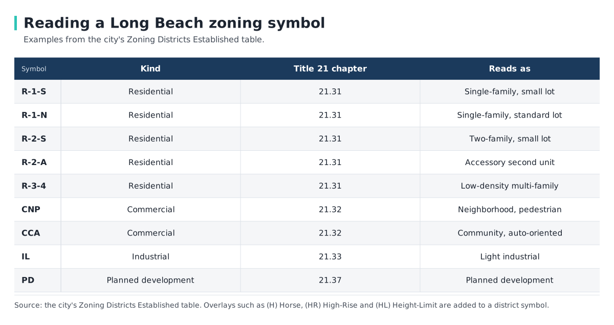
The “Zoning Districts Established” table decodes each symbol and points to the chapter of Title 21 that governs it: 21.31 for residential districts, 21.32 for commercial, 21.33 for industrial and 21.37 for planned development5. Examples in the city’s words:
- R-1-S: “Single-family Residential, small lot”; R-1-N: “standard lot”.
- R-2-S: “Two-family Residential, small lot”; R-2-A: “Two-family Residential, accessory second unit” (21.31).
- R-3-4: “Low-density Multi-family Residential”.
- CNP: “Neighborhood Pedestrian-Oriented Commercial”; CCA: “Community Commercial Automobile-Oriented”.
- IL: “Light Industrial”; PD: “Planned Development” (21.37).
- Overlays: (H) Horse, (HR) High-Rise, (HL) Height-Limit.
The same table lists districts from the newer Title 22: RMU3, RMU4, MU-1, MU-2, MU-3, MFR-L, MFR-M, C3, NI-1 and NI-25. MFR-L and MFR-M appear both there, as Title 22 districts, and in the PlaceType list below6.
The 14 PlaceTypes
PlaceTypes belong to the General Plan, not to the zoning code. The Land Use Element adopted in December 2019 lists 14: OS, N, MFR-L, MFR-M, NSC-L, NSC-M, TOD-L, TOD-M, CC, I, NI, RSF, DT and WF6. The families are open space, neighborhoods, multi-family, neighborhood-serving centers, transit-oriented, community commercial, industrial, neo-industrial, regional-serving, downtown and waterfront6.
The element gives examples of what a PlaceType allows. The neighborhood PlaceType, “Founding and Contemporary Neighborhood”, is described as “7-18 du/ac … 2 stories”; MFR-Moderate as “Up to 62 du/ac … 6 stories”6. Its policy reads “the PlaceTypes and Zoning Districts are to be consistent with each other”6. Read together, the PlaceType is the General Plan’s label for an area, while the zoning district is the classification the Zoning Regulations attach rules to16.
UPLAN, Title 22 and Zone In
Good to know UPLAN is not a PlaceType glossary. It is the “Uptown Planning Land Use and Neighborhood Strategy” for North Long Beach. Phase 1 began in 2018 and ended in November 2020 with new zoning for the Atlantic and Artesia corridors and “the establishment of Title 22, the City’s new zoning code which will ultimately replace the 1989 code found in Title 21”. Phase 2 “was completed in September 2024” with four new zoning districts and a Neighborhood Mobility Enhancement Plan7.
The citywide program that carries Title 22 forward is called Zone In. The city says the zoning code “has not been comprehensively updated since 1989”7. The city’s Zone In pages list Bixby as adopted June 9, 2026; City Core (formerly ACZIP) with documents “Adopted October 1, and in effect October 31”, a line that prints no year; WestLB as adopted May 2, 2023; Wrigley and 10th Street to Broadway as in progress; and “Everyone’s Coast”, covering Alamitos Avenue to Naples Island south of Broadway89. Title 21 continues to apply to areas not yet rezoned78.
The zoning confirmation letter and related fees
The city’s Planning schedule prices the written answer. The schedule is in force from October 1, 2026, and the schedule shows each fee at its base and with a 12.0 percent surcharge, saying “Fee with surcharge applies”10.
| Planning fee, as of October 2026 | Base | With surcharge |
|---|---|---|
| Zoning Confirmation Letter | $1,020.00 | $1,142.40 |
| Zoning Administrator Interpretation (“Per Section 21.10.045”) | $1,429.00 | $1,600.48 |
| Business License Zoning Review | $191.00 | $213.92 |
| Business License Zoning Review, home occupation | $52.00 | $58.24 |
Source:10.
The schedule lists the letter by name and does not describe what it contains. Fees “are based on the fee schedule in effect at the time the application submittal is completed”10. How the letter figures in a lease decision is in Zoning Check Before You Sign a Long Beach Lease.
Frequently Asked Questions
How do I find my zoning in Long Beach?
What does R-1-S mean in Long Beach?
The city’s district table reads it as “Single-family Residential, small lot”; R-1-N is the “standard lot” version5.
What is a PlaceType in Long Beach?
A General Plan designation from the December 2019 Land Use Element, which lists 14. The policy says PlaceTypes and zoning districts are to be consistent6.
What is UPLAN in Long Beach?
The Uptown Planning Land Use and Neighborhood Strategy for North Long Beach, whose first phase established Title 227.
How much is a zoning confirmation letter in Long Beach?
As of October 2026, $1,020.00 base, or $1,142.40 with the 12 percent surcharge10.
What is Title 22 in Long Beach?
The city’s new zoning code, which “will ultimately replace the 1989 code found in Title 21”7.
Related Articles
Sources
- Zoning lookup: Zoning and Land Use GIS Map — City of Long Beach, Development Services. Accessed 2026-10-02.
- Zoning Maps — City of Long Beach, Development Services. Accessed 2026-10-02.
- Maps Directory — City of Long Beach, Development Services. Accessed 2026-10-02.
- Zoning maps and related map layers — City of Long Beach, Development Services. Accessed 2026-10-02.
- Zoning Districts Established — City of Long Beach, Development Services. Accessed 2026-10-02.
- Land Use Element, adopted December 2019 — City of Long Beach, Development Services. Accessed 2026-10-02.
- UPLAN LB — City of Long Beach, Development Services. Accessed 2026-10-02.
- Zone In — City of Long Beach, Development Services. Accessed 2026-10-02.
- Zone In area status — City of Long Beach, Development Services. Accessed 2026-10-02.
- Planning Bureau Fee Schedule, October 1, 2026 — City of Long Beach, Development Services. Accessed 2026-10-02.
- MapsLB — City of Long Beach. Accessed 2026-10-02.